
GISCorps Volunteer Helps Israeli Palestinian Confederation with Reviewing their RFP
The Israeli Palestinian Confederation (IPC) is a California-based nonprofit organization working to develop a framework for peaceful cooperation and shared governance between Israelis and Palestinians. As part of this effort, IPC is interested in hiring a private GIS company to develop a series of products including multiple online maps, collecting underlying and necessary datasets, and building various GIS models to improve the representation and governance in that area.
To support this effort, IPC has prepared a draft Request for Proposals (RFP) and requested the assistance of a GISCorps volunteer to review the document and provide expert feedback and recommendations.
The primary responsibility of the GISCorps volunteer is to review, evaluate, and provide recommendations for improving the draft RFP. This includes ensuring that the project’s technical, analytical, and operational requirements are clearly defined and effectively communicated by IPC.
Following the volunteer recruitment process, GISCorps volunteer Amanda Stanko of Redlands, California, was selected to support this project.
Recruitment complete, project in progress.

GISCorps Volunteer Assisting Keep Bermuda Beautiful
Keep Bermuda Beautiful (KBB) is a non-profit organization with a mission to engage individuals to take greater responsibility in reducing waste and eliminating litter through action and education. By promoting litter prevention, waste reduction, and beautification, KBB works to create a cleaner, greener, and more beautiful Bermuda for everyone.
KBB requested a GISCorps volunteer to assist in developing a survey for the public to report abandoned objects, a Dashboard to monitor reported abandoned objects, and an automated email notification to KBB staff when new surveys are submitted.
Following the recruitment, Emily Lopez, a GISCorps volunteer in Virginia, was selected for this project.
Recruitment complete, project in progress.
GISCorps Volunteer Supports Save Texas Moms in Improving Maternal Health Outcomes
Save Texas Moms (STM) is a nonprofit organization dedicated to improving maternal health outcomes across Texas by bridging the gap between families, providers, and the resources they need. STM works at the intersection of data, advocacy, and community action. They serve mothers, families, healthcare providers, and policymakers with geographic intelligence that reveals where access to quality maternal care falls short and where intervention is most urgently needed. This work directly supports communities affected by Texas’s maternity care deserts, helping identify and address gaps in care for underserved mothers and families across the state.
To support this mission, a GISCorps volunteer support was requested to audit, consolidate, and elevate STM’s existing ArcGIS Online (AGO) datasets into a unified intelligence platform. The volunteer will resolve inconsistencies across mixed data sources, establish documented workflow architectures, and launch a flagship ArcGIS Dashboard to clearly visualize access gaps. To reach Texas’s diverse communities, the project will prioritize mobile accessibility and Spanish-language accessibility, potentially expanding into custom StoryMaps or ArcGIS Experience Builder sites for different public and policymaker audiences. To ensure long-term sustainability, the volunteer will also deliver written and recorded training materials, collaborating with university interns and STM staff to build lasting internal capacity.
Following the recruitment, Thailynn Pinkney, a GISCorps volunteer in Colorado, was selected for this project.
Recruitment complete, project in progress.

GISCorps Volunteer Assisting Highway 13 Butterfly Trail
Highway 13 Butterfly Trail (HBT) is a community-driven conservation and tourism initiative located along Highway 13 in Missouri, spanning multiple counties and communities. The project aims to create a corridor of pollinator-friendly habitats, butterfly gardens, native plantings, educational sites, and tourism destinations that support monarch butterflies and other pollinators while promoting environmental stewardship and economic development.
HBT has requested GISCorps for a volunteer to provide GIS, cartographic, and technical consulting support. The primary objectives of the project are to assess and organize existing GIS data and mapping resources, refine the current Highway 13 Butterfly Trail map, and create a professionally designed large-format map suitable for outdoor metal signage. The volunteer will also provide technical guidance on GIS workflows, data management, and future mapping opportunities, including building StoryMaps and dashboards. In addition, the project includes conducting spatial and demographic analyses along the corridor to generate meaningful statistics that can support grant applications, conservation planning, and project reporting.
The volunteer will serve as both a technical consultant and expert cartographer, helping transform existing mapping products and data into high-quality visualizations and analytical outputs that support the organization’s conservation, tourism, and outreach goals.
Following the recruitment, Kevin Clark, a GISCorps volunteer in Maryland, was selected for this project.
Recruitment complete, project in progress.

GISCorps volunteer takes Lee-Harvard Memorial Project’s StoryMap to the next level
Lee-Harvard Memorial Project (LHMP) is a community-driven initiative dedicated to preserving and celebrating the history, culture, and legacy of Cleveland’s Lee–Harvard neighborhood. The project aims to create a meaningful public memorial space that honors the contributions, resilience, and lived experiences of community members while strengthening local identity and historical awareness. Through storytelling, public engagement, art, and historical research, LHMP seeks to highlight the neighborhood’s significance and preserve its history for future generations. Central to the initiative is a collaborative approach that brings together residents, local leaders, historians, and artists to ensure the memorial authentically reflects the voices and experiences of the community.
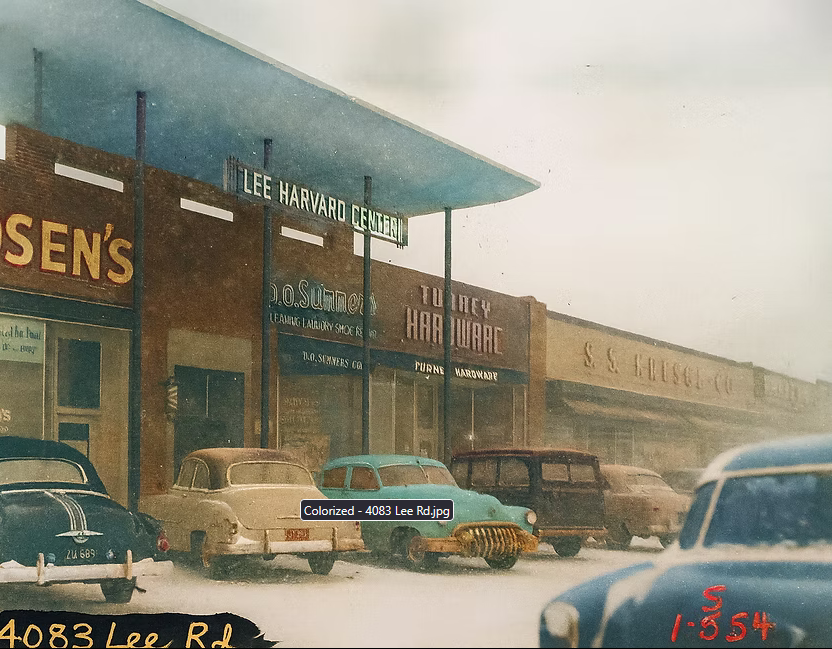
To support this vision, LHMP worked with a university student that built a StoryMap. The collaboration demonstrated the capability of a StoryMap, however, they are now interested in further expanding the content and capabilities of the existing StoryMap. They are also very interested in becoming trained by the GISCorps volunteer to be able to sustain their platform on their own. Planned enhancements include embedding oral histories through audio and video recordings, incorporating short-form video content, and integrating historical and contemporary imagery with an interactive swipe functionality for before-and-after comparisons. In addition, LHMP would like to create opportunities for community members to contribute their own stories, photographs, and artifacts directly to the project. LHMP seeks support from a GISCorps volunteer to help enhance the interactive StoryMaps and add Survey123 forms to support these community engagement and storytelling efforts.
Following the recruitment, Alicia Tyson, GISCorps volunteer based in Colorado, is selected for this project.
Recruitment complete, project in progress.

PhotoMappers Admin Team
2025 Update:
The 2025 #PhotoMappers Admin team included Johnathan Clementi, Brad Fisher, Mackenzie Fox, John Haddad, Keith Johnson, Madeline Jones-Franconi, Monicque Lee, Cara Maney, Jennifer Pramuk, Emilie Pratt, and Dacey Zelman. Erin Arkison was joined by newcomers Rob Carroll, and Hannah Gonzales-Bridges to comprise the GISCorps Disaster Response Subcommittee. From NAPSG Foundation, Emma Montague provides technical support to maintain the #PhotoMappers apps, while Jared Doke and Tari Martin manage connections with emergency managers.
2024 Update:
The 2024 #PhotoMappers Admin team included Jonathan Clementi, Brad Fisher, Mackenzie Fox, Hannah Gonzales, John Haddad, Hannah Larsen, Keith Johnson, Emilie Pratt, Jason San Souci, and Dacey Zelman-Fahm. Erin Arkison, Holly Torpey, and Katie Picchione continue as the GISCorps Disaster Response Subcommittee as well as our newest member Monicque Lee. Rob Neppell of CEDR Digital Corps also supports the project. From NAPSG Foundation, Emma Montague provides technical support to maintain the PhotoMappers apps, while Jared Doke and Tari Martin manage connections with emergency managers.
2023 Update:
The 2023 #PhotoMappers Admin team included Jonathan Clementi, Brad Fisher, Mackenzie Fox, Hannah Gonzales, John Haddad, Hannah Larsen, Keith Johnson, Emilie Pratt, Jason San Souci, and Dacey Zelman-Fahm. Erin Arkison, Holly Torpey, and Katie Picchione continue as the GISCorps Disaster Response Subcommittee. Rob Neppell of CEDR Digital Corps also supports the project. From NAPSG Foundation, Emma Montague provides technical support to maintain the PhotoMappers apps, while Jared Doke and Tari Martin manage connections with emergency managers.
2022 Update:
The 2022 #PhotoMappers Admin team included Kelli Brock, Jonathan Clementi, Brad Fisher, Mackenzie Fox, Hannah Gonzales, John Haddad, Kenny Hornfeldt, Hannah Larsen, Keith Johnson, Emilie Pratt, Jason San Souchi, and Dacey Zelman-Fahm. Over the last two years, the GISCorps Disaster Response Subcommittee, which manages the project, has grown to include Erin Arkison, Holly Torpey, and Katie Picchione. Rob Neppell and Melissa Swenson of CEDR Digital Corps also support the project. On the NAPSG team, Adam Fackler keeps the PhotoMappers apps up to date, and Jared Doke and Tari Martin keep the team connected with emergency managers.
2021 Update:
GISCorps is entering its fifth year providing volunteer support for NAPSG Foundation’s Crowdsourced Disaster Photo mapping program. Also known as #PhotoMappers, this team of volunteers finds and maps crowdsourced photos of on-the-ground conditions during natural disasters in the United States and its territories. To date, hundreds of GISCorps volunteers have geolocated thousands of photos, providing a valuable source of situational awareness that federal, state, and local emergency managers have come to rely on as they assess initial impacts and allocate resources. Each of those photos is validated by the small but mighty PhotoMappers Admin Team. The Admin team not only reviews each upload for relevance and accuracy, but they also assign a primary FEMA Community Lifeline and an initial damage assessment score to each photo. They also provide support to the rest of the PhotoMappers volunteers. In 2021, the Admin Team vetted over 1,000 photos and volunteered over 190 hours!
Led by Erin Arkison, the 2021 PhotoMappers Admin Team includes Kelli Brock, Christina Brunsvold, Johnathan Clementi, Tiffany Drummond, Brad Fisher, John Haddad, Kenny Hornfeldt, Keith Johnson, Hannah Larsen, Katie Picchione, Jason San Souci, Alicia Tyson, and Dacey Zelman-Fahm.
Mid-2020 Update:
To keep up with this busy season, three additional volunteers have joined the NAPSG Crowdsourcing Admin Team. Welcome, Johnathan Clementi, Kenny Hornfeldt, and Sean Lim!
2020 Update:
With the NAPSG Crowdsourcing application expanding to earthquakes and tornado events, as well as being on standby for the 2020 hurricane season, GISCorps polled the 2019 admin volunteers for their availability in 2020. Christina Brunsvold, John Haddad, and Dacey Zelman-Fahm are continuing with the team, along with new member, Alicia Tyson from Alabama. Two members, Eadie Kaltenbacher and Melvin Nforba are on to new endeavors. We wish them well and thank them for their services in 2019. Erin Arkison has joined the GISCorps Core Committee and will be working with German Whitley leading the Disaster Response Subcommittee.
The team continues to evolve the apps and dashboards as well as improving and refining workflows for different types of disaster events.
2019 Team:
Building on a series of successful collaborations in the last year following Hurricanes Florence, Michael, and Barry, NAPSG Foundation, CEDR Digital Corps, and GISCorps have been hard at work preparing for the remainder of the 2019 hurricane season. Together, we’re ready to continue providing on-the-ground situational awareness to emergency managers and first responders with the 2019 Hurricanes Crowdsourced Photos Story Map.

In addition to updating applications and reworking workflow documentation, GISCorps project manager German Whitley has assembled a team of seasoned hurricane project contributors to serve as the Admin Team for future projects. The GISCorps 2019 Hurricane Season Admin Team includes Erin Arkison from Texas, Christina Brunsvold from California, John Haddad from Colorado, Eadie Kaltenbacher from Oregon, Melvin Nforba from Maryland, Holly Torpey from California, and Dacey Zelman-Fahm from New Zealand.
Working alongside Paul Doherty of NAPSG and Rob Neppell of CEDR Digital Corps, these experienced and dedicated volunteers will validate photo submissions for accuracy and formatting and assign FEMA Community Lifeline categories. They’ll mine social media for imagery that can be geolocated, and they’ll help keep our applications up and running and our documentation current. Perhaps most importantly, they’ll be on hand in our shared Slack channels to support other GISCorps volunteers as they geolocate photos and video and add them to the map.
Recruitment complete, mission in progress.
GISCorps Volunteer Assisting Global Opportunities Unlimited with Esri Application Development
Global Opportunities Unlimited (GO Unlimited) of Albuquerque, NM, was founded in August 2005, with a mission to help people with compromised mobility participate in outdoor adaptive sports and recreation activities. Navigating both water and land, GO Unlimited has become an international leader in design, build, technology, and services creating mobility solutions for various outdoor recreational interests. GO Unlimited tests new technology and designs in its home state of New Mexico. Those products are then incorporated into local recreational involvement by the disability community. GO Unlimited views individual connections with the outdoors as a necessity for the health and wellbeing of both human and our planet. Through working with a collective local and global professionals, GO Unlimited is raising awareness about the interconnections between outdoor recreation, health, education and employment.
GO Unlimited collaborates with the New Mexico State Parks Division and other land managers to evaluate how accessible existing outdoor recreational infrastructure is, including facilities, trails, campgrounds, etc. This effort helps individuals with disabilities find suitable opportunities while also enabling GO Unlimited to identify gaps to enhance and expand accessible infrastructure.
GO Unlimited requested GISCorps assistance in developing a field data collection application to capture accessibility information at existing outdoor recreational sites, a public-facing application that serves as a resource to individuals with disabilities, and an internal application to identify gaps and potential improvement projects.
Following the recruitment, Chris Caro, a GISCorps volunteer in Albuquerque, New Mexico, was selected for this project.
Recruitment complete, project in progress.
