Global MapAid (GMA) is a US & UK based non-profit organization with a passion and…
Global MapAid (GMA) is a US & UK based non-profit organization with a passion and vision to create maps for solving development problems. One current project involves the creation of an Artificial Intelligence system to help determine where to put shallow boreholes for small farmer irrigation in Ethiopia. With the knowledge of where to place irrigation wells, the shallow well drilling sector can help improve food production by up to three times, versus a rainfall-only scenario. Currently, there is a lack of enough hydrogeologists to perform siting of these wells, hence the need for the AI system as a support tool.
Currently, the UN has estimated as much as 40% of the 110 million population are under-nourished, while the country spends $400 million per year on emergency feeding schemes for 8 million of the worst affected people.
GMA requested the assistance of a GISCorps volunteer to serve as a GIS mentor to a PhD student, within a friendly team of multidisciplinary skilled volunteers, who are also supporting the student and the development of the AI. This team is a collaboration between George Mason University, Arba Minch University, and Global MapAid with support from the Czech Geological Survey.
Jay Parrish was selected to help with this project. During the two years he has helped with this project as part of the team, they have been evolving an AI trained model (known as Modelling Optimal Drilling Locations, or MODL) – for determining where to place shallow irrigation boreholes in Ethiopia. Jay has contributed to this large project to help find, refine and organize the factors that affect static water levels, especially with regard to geological factors, which is his area of expertise. This has helped the study to create a groundwater map that provides guidance for drilling boreholes for agricultural irrigation.
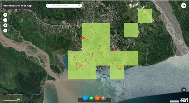
The current project to date has produced a technical report and is proceeding with prototype maps predicting groundwater levels in Bilate, Ethiopia using a random forest regression model based on 75 existing boreholes. Future work will involve seeking additional data on existing boreholes to improve the quality of the model and to work on groundwater recharge estimation, finding optimal drilling locations, and continuously evolving a decision support tool. Once these items are complete, the technical report will be updated, and eventually, the study will be used as guidance for drilling boreholes for sustainable irrigation and drinking water.
Global MapAid is delighted with Jay’s contributions and eagerly look forward to future work with GISCorps.
Project Complete

Related Missions