Save Texas Moms (STM) is a nonprofit organization dedicated to improving maternal health outcomes across…
Walking is one of the simplest ways to connect with a community, yet there can be many obstacles that prevent this experience from being accessible, safe, and enjoyable for everyone. Queensland Walks, a nonprofit organization based in Australia, is working to change that. This organization is dedicated to creating more walkable communities where people of all ages and abilities feel comfortable walking, rolling, or strolling as part of everyday life. Through collaboration with local governments, community organizations, and advocacy groups, the organization promotes policies and investments that improve walkability, accessibility, and public safety.

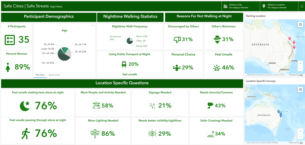
One of their signature initiatives, Safe Cities | Safe Streets for Women and Girls, invites women and girls to participate in community walkshops where they share their experiences of moving through public spaces, particularly after dark. Participants identify locations where they feel safe or unsafe and explain the factors that influence those feelings. These local perspectives provide valuable insights that help planners and decision-makers better understand how the built environment influences personal safety.
Queensland Walks also gathers community data through the Walk My Streets survey which evaluates the nine essential elements of a walkable community: footpaths, crossings, connections, direction, protection, safety, amenity, accessibility and community. Open to anyone at any time of day or night, the survey allows residents to share observations about conditions that affect their walking experience.
By combining community knowledge with geographic information systems (GIS), Queensland Walks is transforming individual experiences into meaningful data that will help to create safer, more inclusive public spaces.
The Challenge
As participation in the Safe Cities | Safe Streets and Walk My Streets programs continued to grow across Australia, Queensland Walks recognized the need to modernize its data collection and reporting processes. Over time, the organization used multiple Survey123 forms and reporting workflows to support their work. While effective, these workflows had become increasingly difficult to maintain, particularly as more communities joined the programs. Historical data was stored in different formats, making it challenging to compare results or share a consistent story across projects.
Queensland Walks needed a solution that would streamline data collection, improve reporting, and provide an easier way for staff and volunteers to manage the program well in the future.
The GISCorps Solution
Working alongside Queensland Walks, GISCorps volunteers helped redesign the organization’s Web GIS workflow from data collection through analysis and reporting.
The first step was simplifying how information was collected. Separate ArcGIS Survey123 forms previously used for daytime and nighttime Walk My Street surveys were combined into a single survey, creating a more intuitive experience for participants and facilitators. The Safe Cities | Safe Streets surveys were also redesigned with a more flexible, reusable format, eliminating the need to create new surveys for each event. These improvements increased consistency across all programs leading to easier data management and a more sustainable workflow as the programs continue to grow.
The second step was consolidating historical survey data into new hosted feature layers in ArcGIS Online, creating a single authoritative dataset for each program’s current and future reporting. This allows Queensland Walks to analyze trends over time, compare results across communities, and reduce effort managing multiple datasets.
To help communicate the results, two interactive ArcGIS Dashboards were developed. The Safe Cities | Safe Streets dashboard provides a dynamic view of participant responses through maps, charts, and summary statistics, allowing community members and stakeholders to explore findings from all walkshops or filter the results on a specific location or area of interest.
The Walk My Streets dashboard provides a detailed view of program activities across participating Local Government Areas throughout Australia. The dashboard allows Queensland Walks staff to monitor participation, compare community feedback, and better understand how perceptions of safety and walkability vary between locations. This interactive format will be a powerful tool during presentations and discussions, helping demonstrate community needs and support the case for targeted improvements.
Behind the scenes, Arcade expressions were used to automate calculations for key walkability and safety indicators. Instead of manually calculating scores after every event, the dashboards update automatically, providing immediate insights while ensuring consistent reporting. Finally, detailed documentation and workflow guides were created so that Queensland Walks staff and volunteers can confidently maintain and expand the system as the program continues to grow.
Project Outcomes
The project delivered several important improvements for Queensland Walks, including:
- Redesigned Survey123 forms that supports both daytime and nighttime walkshops.
- Consolidated hosted feature layers containing both current and historical participant responses.
- Two interactive ArcGIS Dashboards that communicate results to both the public and internal staff.
- Automated calculations for the nine key elements of walkability:
- Lighting
- Visibility
- Activity
- Safety
- Accessibility
- Wayfinding
- Comfort
- Maintenance
- Community Presence
- Comprehensive documentation and knowledge transfer resources that will support future staff and volunteers.

Lasting Impact
This project has given Queensland Walks more than new GIS tools; it has provided a sustainable workflow that will continue supporting communities long after the volunteer engagement has ended.
By simplifying data collection, automating analysis, and improving visualization, Queensland Walks can now spend less time managing data and more time working with communities to improve public spaces.
The new dashboards transform participant experiences into clear, accessible information that helps local governments, planners, and community organizations identify where improvements are needed most. More importantly, the standardized workflows and documentation ensure that future staff and volunteers can continue building on this work without starting from scratch.
Ultimately, the project demonstrates how GIS can amplify community voices and turn local experiences into evidence that supports safer, more welcoming neighborhoods.
Volunteers’ Reflection
“Volunteering with GISCorps on the Queensland Walks project was both meaningful and professionally rewarding. It was exciting to use GIS to support an organization whose work has a direct impact on people’s everyday lives.
Throughout the project, we helped simplify the organization’s Survey123 data collection process, integrate historical information into a single hosted dataset, develop interactive dashboards, automate walkability calculations using Arcade, and prepare documentation that will allow Queensland Walks to maintain the system independently.
What stood out most to us was seeing how GIS can give a stronger voice to community members. Every point on the map represents someone’s personal experience, and together those experiences become powerful evidence that can influence planning, policy, and investment. Knowing that our volunteer work can help create safer, more walkable communities is incredibly rewarding.
We are grateful to GISCorps for providing opportunities to apply geospatial skills in service of organizations that are making a genuine difference around the world.”
Project Complete

Related Missions