
Overview The #PhotoMappers project is in its 11th year of providing situational awareness to federal,…
Overview
Now in its fifth year of providing situational awareness to federal, state, and local emergency managers, the PhotoMappers team is responding to the 2021 hurricane season. PhotoMappers is an ongoing partnership between NAPSG Foundation, CEDR Digital Corps, and GISCorps; learn more about previous seasons here.
In this series of missions, GISCorps volunteers work together scouring social media and news outlets to find publicly shared photos of on-the-ground conditions and damage in areas affected by natural disasters. Collaborating in a dedicated Slack channel, team members carefully geolocate each photo using clues in the image or the accompanying text. They then upload them using a Survey123 form embedded in a Volunteer Portal built in Experience Builder. Each photo is vetted by a specially trained Admin Team member who also adds a primary lifeline and a damage score.

Photos that have been vetted are viewed by emergency managers and first responders on maps and dashboards. These applications, as well as the raw data, are publicly available on NAPSG’s PhotoMappers Hub Site.

2021 Activations
Deep South Tornadoes
On March 25th and 26th, dozens of tornadoes touched down in Georgia and Alabama while thunderstorms and flooding affected Tennessee and Kentucky. A small team of experienced volunteers jumped in on short notice to map photos of damage caused by these destructive events: Austin Adkison, John Haddad, Keith Johnson, Ingrid Jourgensen, Tari Martin, Rebecca Parsons, and Katie Picchione each participated in this mission, which was managed by GISCorps Core Committee member Erin Arkison with assistance from Holly Torpey.

Project Complete.
Tropical Storm Henri and Tennessee Flooding
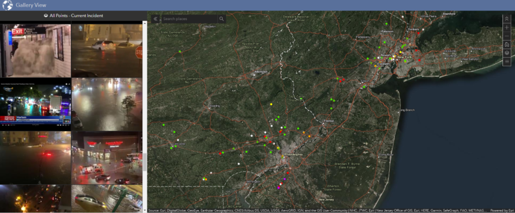
After being downgraded from a Category 1 hurricane, Tropical Storm Henri made landfall on the Rhode Island coast as a tropical storm on Sunday, August 22, 2021. Starting on Saturday, a team of 22 GISCorps volunteers scoured social media and news outlets for photos of conditions on the ground. The volunteers started off mapping photos of storm preparations, evacuations, and supply shortages, transitioning on Sunday to photos of flooding and wind damage as the storm began to affect the Northeast. By Monday evening, the team had found, geolocated, and uploaded over 185 photos in Pennsylvania, New Jersey, New York, Connecticut, Rhode Island, and Massachusetts. Ten Admin Team members vetted each submission for locational accuracy and attribute completion, screening for duplicates and adding a primary FEMA Community Lifeline and a building damage score to each photo.
On Sunday, the team leaders were contacted by federal emergency managers with a second request. A localized storm system had dropped 17 inches of rain on Humphreys County, Tennessee, causing catastrophic flash floods that swept away houses, cars, and families with little or no warning, killing dozens of people. A few of the GISCorps volunteers who were already working on the Hurricane Henri activation pivoted to finding and geolocating photos of conditions in Tennessee, mapping 22 photos of damage and debris in the area.
On Monday, federal emergency managers returned with a second request. StormPoint Emergency Response had provided them with aerial videos of the affected area captured by Unmanned Aircraft Systems (UAS), but the footage lacked location information. Project leaders reviewed 15 UAS videos, captured screenshots of damage that could be accurately geolocated, and added them to the PhotoMappers map to contribute to rapid damage assessment. An additional 25 images were mapped in this way, for a total of 47 photos of damage in Humphreys County.

The following volunteers contributed to the Hurricane Henri and Tennessee Flooding missions: Hannah Larsen, Alicia Tyson, Brad Fisher, Keith Johnson, Paul Paddock, Katie Picchione, Elena Kraus, Kelli Brock, Mollie Nugent, Vickery Cleveland, Jason San Souci, Alyssia Church, Nicholas Chiavini, Dacey Zelman, David Thell, Kenny Hornfeldt, Johnathan Clementi, Kalen Johnson, Luke Potash, and Miranda Harvey. The mission was led by Erin Arkison and German Whitley with support from Holly Torpey. The requesting partner was NAPSG Foundation.
Project Complete.
Hurricane Ida
Hurricane Ida made landfall as a Category 4 hurricane near Port Fourchon, Lousiana, on August 29th, 2021. The powerful storm left extensive flooding, severe wind damage, and widespread power outages across Southeastern Louisiana before weakening to a tropical depression as it moved northeast across the United States. On NAPSG Foundation’s request, GISCorps volunteers began mapping photos of evacuations and storm preparation measures on August 28th, ramping up efforts on the 29th as damage photos began to appear on social media and news outlets.

Anticipating flooding in the Southeastern United States and Appalachia as the storm moved back toward the Atlantic, the volunteers continued finding and mapping photos on August 30th and 31st, expecting to close out the project as the storm weakened. Instead, Ida began a second wave of destruction as it moved through the Mid-Atlantic and Northeastern United States, producing multiple tornadoes and catastrophic flash flooding that took dozens of lives in several states.
By the time the mission leaders closed out the mission on September 2nd, GISCorps volunteers had mapped and categorized over 600 photos, and the PhotoMappers Public Portal had been viewed about 3,000 times.

The following volunteers mapped photos for the Hurricane Ida mission: Hannah Larsen, Paul Paddock, Emilie Pratt, Brad Fisher, Mollie Nugent, Sadie Barker, Keith Johnson, Kelli Brock, Johnathan Clementi, Alicia Tyson, Alyssia Church, Mackenzie Fox, Micah Babinski, Hannah Gonzales, Ingrid Jourgensen, Darby Levin, Thao Nguyen, Vickery Cleveland, Mark Gobbie, Katie Picchione, Nicholas Chiavini, Todd Kesselring, David Thell, Christina Black, Kenny Hornfeldt, Miranda Harvey, Jason San Souci, John Haddad, and Alix Vezina. All submissions were reviewed and enriched with damage scores and FEMA Community Lifelines by these Admin Team members: Keith Johnson, Hannah Larsen, Tiffany Drummond, Alicia Tyson, Johnathan Clementi, John Haddad, Kenny Hornfeldt, Jason San Souci, Kelli Brock, and Katie Picchione. The mission was led by Erin Arkison and German Whitley with support from Holly Torpey.
Project Complete.
Quad State Tornadoes
On the night of December 10th, 2021, a series of severe tornadoes, including one that traveled over 200 miles, caused extensive damage in Arkansas, Tennessee, Missouri, Illinois, and—most severely—Kentucky. Over 100 lives were lost amid damaged homes and buildings, and whole sections of towns were left unrecognizable. Much of Mayfield, KY, in particular, was devastated. In the following days, Governor Andy Beshear called this the worst tornado Kentucky has ever had.
Responding to a rapid request from the NAPSG Foundation on the morning of December 11th, GISCorps volunteers began mapping publicly-posted photos found on social media and other internet sites. Within 36 hours, volunteers located, mapped, and vetted over 170 photos of damage across the five states. During this incident, the team received word that PhotoMappers data was used for early situational awareness, incorporated into maps for search and rescue teams, and used to conduct and validate virtual damage assessments.

During this activation, CEDR Digital Corps provided an experimental bot to help find tweets with informative photos. The NAPSG Foundation also provided data to help volunteers focus the search for new photos.
Initially only the PhotoMappers Admin Team activated for the Quad State Tornado mission, and the following members supported: Keith Johnson, Hannah Larsen, Johnathan Clementi, Brad Fisher, and Alicia Tyson. Toward the end of the first day, several additional volunteers stepped in to help map photos: Ingrid Jourgensen, Emilie Pratt, Nicholas Chiavini, and Madie Jones.
The mission was led by the Core Committee member Katie Picchione with support from Erin Arkison. Special thanks to Advisory Board members German Whitley and Holly Torpey, who made this mission possible.
Project Complete.
Historical Incident Viewer
Use the application below to browse photos from past activations. Click the down arrow to select an incident.
Related Missions


