
The Protected Area Management (PAM) initiative is a partnership between the National Geographic Society, Esri,…
The West East Community Access Network (WE CAN) Foundation is a nonprofit based in Los Angeles, California. WE CAN was founded over 20 years ago with the objective of bridging the digital divide in underrepresented communities in South Central Los Angeles. WE CAN has begun tackling issues of sustainability in that community by educating residents about the benefits of urban agriculture and drought-tolerant landscaping.
WE CAN Foundation President Kenneth Wyrick and Executive Director Dr. Michél McLaughlin approached GISCorps to learn more about the potential for using GIS to track and promote their sustainability initiatives. GISCorps volunteers Alice Kim and John Schweisinger were selected to perform an on-site needs assessment to evaluate WE CAN’s requirements and suggest an affordable and useful solution. Alice and John met with WE CAN volunteers to conduct an assessment.
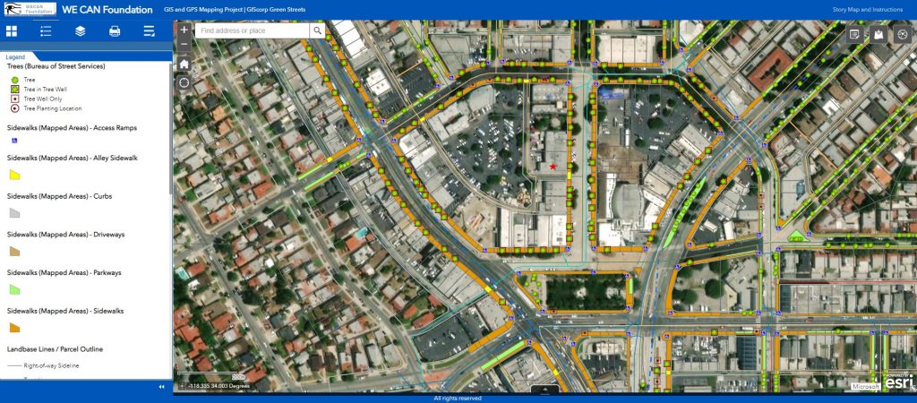
Following the initial needs assessment, John continued his involvement with WE CAN, creating a web map in ArcGIS Online to serve as a framework for developing a Green Infrastructure Inventory within the project area. This framework would put GIS in the hands of community leaders, enabling them to create a site map of Green Infrastructure Projects.
Developing the GIS framework consisted of three steps:
- Obtaining and symbolizing GIS data layers to help view important features.
- Developing an interface where users can delineate areas that are optimal for Green Infrastructure Design.
- Calculating the areal extent of these features for grant funding applications and construction projects.
Working with WE CAN, GISCorps, and the University of Southern California’s Spatial Sciences Institute, where he is a part-time graduate student, John was able to create this web interface. The map incorporated aerial imagery and LiDAR data to identify and exclude impervious surfaces and areas of high slope. Community Plan Areas and Neighborhood Council Boundaries were used to define an area of interest. Using the web map, community members are able to draw in areas of potential Green Streets, helping to beautify South Central Los Angeles and reduce water usage.
John hopes to continue volunteering with WE CAN to support their continued use of GIS to promote urban agriculture and sustainability.
Test drive the live web application here.
Project complete

Related Missions


