
Overview The PhotoMappers project is in its 10th year of providing situational awareness to federal,…
The Protected Area Management (PAM) initiative is a partnership between the National Geographic Society, Esri, and GISCorps. This initiative seeks to facilitate and support the effective use of Esri’s ArcGIS Solutions for Conservation, which has been made available at no cost to protected areas throughout Africa through a partnership between Esri and the National Geographic Society. ArcGIS Solutions for Conservation provides protected area managers with a secure suite of configurable technology for better managing and protecting parks and sensitive conservation areas.
Established in 2007, Grevy’s Zebra Trust (GZT) is dedicated to conserving the endangered Grevy’s zebra and its habitat. The organization collaborates closely with local communities to implement conservation initiatives, combining traditional knowledge with scientific research. Their programs include employing community scouts for zebra monitoring, promoting regenerative grazing practices to restore habitats, and offering educational outreach to raise awareness about conservation. Through these efforts, the Trust aims to ensure the survival of the Grevy’s zebra while supporting sustainable livelihoods for local populations.
Grevy’s Zebra Trust is seeking a qualified volunteer with substantial experience in Geographic Information Systems (GIS) to assist in the development of Story Maps that effectively present data analysis supporting ongoing conservation initiatives. GZT is also interested to learn about other AGO products such as Experience Builder, Field Maps, and Quick Capture, as well as receiving recommendations regarding best data management practices in AGO.
Following the recruitment, Rachel George, GISCorps volunteer in Florida, USA was selected for this project and was put in contact with Grevy’s Zebra Trust representatives. The following report was submitted by Rachel George and reviewed by GZT.
Introduction
This project focused on building a public-facing ArcGIS Story Map for the Grevy’s Zebra Trust (GZT) rangelands program while strengthening GIS workflows, so program data becomes easier to update, explore, and share. From the outset, the goal was in two folds: to craft an engaging, museum-like narrative experience, and to integrate practical GIS elements – maps, apps and spatial techniques – that help the data work harder and remain accessible to staff and partners.
The work began with a series of meetings between the GZT team and Rachel to understand GZT’s mission and the breadth of its programs. GZT’s central aim is the preservation of Grevy’s zebra population. Through holistic rangeland practices and deep community engagement, GZT’s strategy connects wildlife recovery to land health and local livelihoods. GZT’s main point of contact, Redempta Njeri, provided a thorough orientation to the rangelands program, sharing reports and the strategic plan, which shaped the structure of the Story Map.
The Story Map
We structured the Story Map in three parts – Grevy’s zebras, regenerative grazing, and community-led restoration – so readers can move from species context to land-management method. The opening section introduces Grevy’s zebras and situates their conservation within GZT’s broader strategy. We experimented with several ways to present program goals before settling on a media-forward map tour inspired by a strategic-plan graphic that linked grass, zebras, land, and community.
Part I: Grevy’s Zebras
Species Overview
Grevy’s zebras are the largest and most threatened of the zebra species, known for their narrow stripes, tall stature, and striking, dish-shaped ears. Fewer than about three thousand remain in the wild. Their survival depends on healthy rangelands, reliable access to water, and coexistence with pastoral communities who share these landscapes. This section introduces the species and sets the stage for how land, wildlife, and people are inseparably linked in northern Kenya.

GZT’s Conservation Goals
The Grevy’s Zebra Trust (GZT) exists to secure a future for Grevy’s zebras by restoring rangeland health and strengthening community stewardship. GZT’s goals connect Grevy’s Zebra recovery to local livelihoods: improve grassland condition, expand safe movement and access to water, reduce threats, and build community capacity to manage grazing and protect wildlife. A graphic from GZT’s strategic plan – showing how grass connects zebras, land, and people – guides the visual narrative for this part of the Story Map and anchors the reader in the core idea that thriving grasslands benefit everyone.

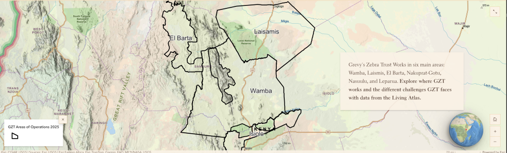
GZT’s Areas of Operation
Grevy’s zebras persist primarily in northern Kenya, with key populations distributed across community conservancies and rangelands that experience strong seasonal dynamics. To help readers locate the story, we begin with a clear view of Kenya, then zoom into GZT’s areas of operation where rangeland regeneration, community grazing management, and restoration projects are underway. We added data from the Living Atlas to help the audience understand movement corridors, water availability, human impact, vulnerable areas, and land cover.
Learn More Through Movement and Sightings
With the species, goals, and places established, the reader can then explore time-enabled data that makes Grevy’s zebra ecology tangible. We have a map and a companion Web Experience to show movement from twenty collared animals beginning in September 2023, letting visitors watch seasonal shifts and compare behaviors across individuals or time. Alongside collar data, a time-enabled sightings map adds human observations, and revealing presence patterns that complement the movement story. Because water shapes both pastoral and wildlife decisions, we layered in precipitation and water-storage context so readers can connect hydrology with where and when Grevy’s zebras choose to be on the landscape.

Part II: Regenerative Grazing – Holistic Land and Livestock Management (HLLM)
The second section explains how GZT applies Holistic Land and Livestock Management (HLLM), a structured approach to planning, implementing, and monitoring grazing to advance ecological, social, and livestock outcomes. To make the method approachable, we used a Sidecar layout with an optional scrolling to guide readers through approximately eleven steps. This format keeps each step concise, visual, and easy to navigate, and reduces scrolling fatigue while preserving detail for those who want it. From there, we illustrate how HLLM translates to practice through grazing blocks and bomas. Grazing blocks are community-demarcated areas used in wet and dry seasons, while bomas are short-stay overnight enclosures—often fortified with invasive plants that rotate roughly weekly. This rotation protects livestock, distributes manure, and allows ground cover to recover through trampling and rest. Quotes, short video clips, and photo swipes deepen the visitor’s understanding of how these tools knit together to regenerate grasslands.
Part III: Community-Led Restoration
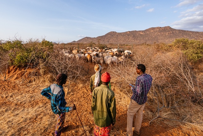
The third section turns the spotlight to community-led restoration. GZT’s Grassland Champions—twelve women in Wamba and ten elders in Laisamis play an essential role in constructing semi-circular bunds, managing indigenous grass seed, and leading outreach. Their work improves grazing conditions and has coincided with a visible increase in Grevy’s zebra presence within grazing blocks, reinforcing the link between rangeland health and wildlife recovery. In the Story Map, we show the efforts GZT is already using with their Survey123 form and the data that is summarized in a dashboard. The Story Map presents these tools alongside documentary photography and statistics so that the Champions’ achievements are front and center.
Following are photos of the Grassland Champions working on the semi-circular bunds. Photo credit: Natalia Mroz


Conclusion
The collaboration with GZT team and in particular Redempta Njeri has been energizing and inspiring. The organization’s commitment to community-anchored conservation is evident in every facet of the rangelands program, from carefully planned grazing to the Grassland Champions’ leadership in restoration. I believe that GZT would benefit from continued support. We did a Story Map on one of their programs, and they have a few more. Also, we did some experimentation with Field Map for some of their surveys, and I believe GZT could benefit from expanding the use of the Field Map and other Esri products. Lastly, we plan to submit our Story Map to the 2025 ArcGIS Story Maps competition.
Project Completed.
Related Missions

