About Umlyngkdait Village Umlyngkdait is a village which is located in the Ri Bhoi District,…
Project Mission
In 2025, I partnered with the Coastal Plains Institute (CPI) to assist with mapping federally listed rare and endangered plant species endemic to the Florida panhandle on the Apalachicola Lowlands Preserve. The mapping objectives were to:
- Create a map of CPIs Apalachicola Lowlands Preserve for educational and outreach purposes.
- Map the distribution of two federally listed plants, White Birds-in-a-nest (Macbridea alba) and Godfrey’s Butterwort (Pinguicula ionantha), since the beginning of their recovery efforts in 2023.
CPI initially began this project in 2023 in collaboration with the Florida Statewide Endangered and Threatened Plant Conservation Program (FPCP). I assisted in 2025, year three of the project.
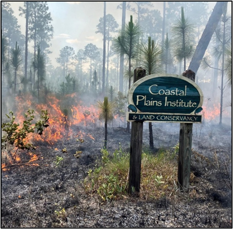
About the Coastal Plains Institute
The Coastal Plains Institute, founded in 1984, is a non-profit organization that works to preserve biodiversity in Florida’s coastal plains through biological research, environmental education, and land restoration. Some of their principal research focuses on the Longleaf Pine ecosystem, ephemeral ponds and the Striped Newt (Notophthalmus perstriatus), as well as on rare and endangered plant species endemic to the Florida panhandle that are both state and federally listed. CPI provides educational opportunities through field trips on foot and by kayaking, classroom visits, lectures, social media, and tabling events. Finally, land management practices on their preserve include thinning out non-native species and using prescribed burns every 1 to 3 years, between April and July, which mimic the natural fire regime of the Longleaf Pine ecosystem.

About the Apalachicola Lowlands Preserve
In 1994, CPI purchased an 80-acre inholding in the Apalachicola National Forest now known as the Apalachicola Lowlands Preserve (ALP). Since 1992, staff have used prescribed ecological burns to transition fire-suppressed land from commercially planted Slash Pine (Pinus elliottii) and densely overgrown Titi (Cyrilla racemiflora and Cliftonia monophyla) back to its natural condition: a savanna of native wiregrass growing beneath Longleaf Pine (Pinus palustris). The preserve also features three seepage bogs and a blackwater stream, and adjoins a 150-acre wet flat in the national forest.
Plant Species of Interest
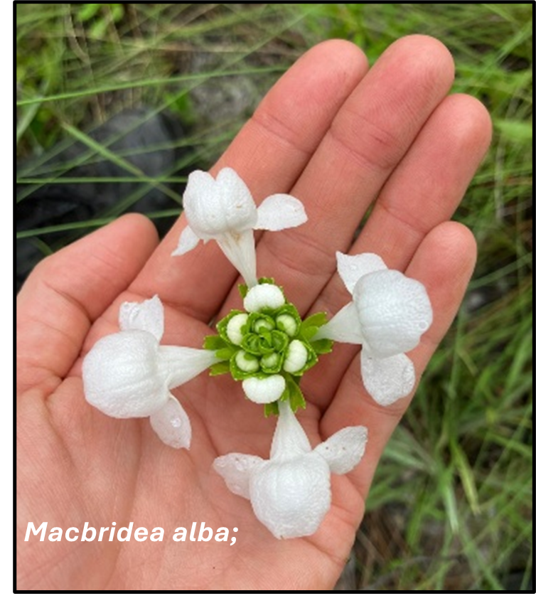
White Birds-in-a-nest (Macbridea alba): Macbridea alba is a federally threatened species endemic to the Florida panhandle and is mostly found in the Apalachicola National Forest. It inhabits mesic pine flatwoods but is highly threatened by fire exclusion, which has led to shrub overgrowth that has choked out this species from its natural habitat. Commercial forestry and the use of heavy machinery have also impacted this species’ survival (Florida Natural Areas Inventory, 2024).
Godfrey’s Butterwort (Pinguicula ionantha): Pinguicula ionantha is also a federally threatened species and is endemic to five counties in the Florida panhandle. The natural habitat for this species is seepage slopes, bogs, depressions in wet pine flatwoods and wet prairies, transition zones between flatwoods/wet prairies and cypress stringers, and roadside ditches (Natural Area Inventory, 2020). Fire suppression,which allows for shrubby overgrowth, heavy machinery on landscapes, and the placement of fire breaks in wetland ecotones, also threatens the conservation status of this species (Natural Area Inventory, 2020).

Project Phase 1: Field Data Collection
Once per year, a field survey for each species is conducted during peak bloom. Peak bloom is the day with the greatest number of blooms at a survey site in a given year; for this research, peak bloom is defined as a single day. Peak bloom is monitored by surveilling the site every other day or daily, leading up to the anticipated peak bloom date. On the day that peak bloom is determined, the survey commences. In the following sections, I discuss the survey method and peak bloom for both species of interest.

White Birds-in-a-nest (Macbridea alba)
Macbridea alba typically blooms from May through mid-July but is also influenced by when fire occurs. On the Apalachicola Lowlands Preserve, Macbridea alba consistently reached peak bloom three months after a prescribed fire. In year one of the project prescribed fire occurred in late May 2023, with peak bloom observed on August 10, 2023. There was no prescribed fire in year two, 2024, and peak bloom occurred on June 28, 2024. In year three, a prescribed fire occurred again in late May 2025, and peak bloom occurred on August 13, 2025. While there were fewer blooms in 2025, the species’ range had expanded significantly. It is predicted that more blooms will be observed in 2026 and 2027, one to two years after the most recent prescribed burn.
On the day of peak bloom, Ryan Means, CPI president and principal investigator, and I surveyed each known survey point. Survey points are marked with a marker rod and survey flag, making them easily visible from year to year. Both stems and blooms are counted because not all stems produce blooms, but stems indicate a plant’s existence. We also measured the distance from each marker rod to the furthest plant at each location to track site expansion over time.
When Macbridea alba was discovered at a new location, a marker rod was established, and the grid coordinates of the new location were recorded. The whole preserve was walked by foot on the day of peak bloom to ensure all potential new locations were identified.
Godfrey’s Butterwort (Pinguicula ionantha)
Pinguicula ionantha typically blooms from late February to April. On the Apalachicola Lowlands Preserve, peak bloom for this species always occurs within the first week of March. CPI chose to study Pinguicula ionantha using survey plots in their most abundant region on the east side of Long Pond, in addition to two survey points.
The survey point data were collected using the same method as the survey points for Macbridea alba; on the day of peak bloom, the number of rosettes and blooms were counted, and the distance from each marker rod to the furthest plant at each survey point was measured to study the spread and distribution with each passing year. The survey of survey plots also occurred during peak bloom, where all rosettes and blooms within each plot were counted. Because rosettes can overlap and create dense clusters, careful examination was required to ensure precise counting. Pinguicula ionantha can also produce one or two blooms per plant, so it is important to count blooms and rosettes to ensure accurate record-keeping.
Since the beginning of this project in 2023, Pinguicula ionantha proves to be thriving and expanding.While 2024 showed a slight dip in rosette and bloom counts, the overall trend is positive, with 2025 setting a record for the highest number of blooms and rosettes ever recorded on the ALP. The positive growth and geographical spread are attributed to the natural ecological fire regime that CPI mimics on this preserve.

General data points for mapping
In addition to the plant surveys, general data points on the preserve were collected to create the maps of the preserve and plant surveys. Using a Trimble TDC600, which has sub-meter accuracy, grid coordinates were collected of the preserve’s corners and the points that marked survey poles and survey plots.

Project Phase 2: Prescribed Burn
As a bonus experience, I assisted with a prescribed burn on the ALP in May 2025. Ryan Means bossed the burn, and I assisted with communication, volunteer coordination, safety, and pulling the drip torch! The burn was completed in one day, and CPI was able to burn some of the densest overgrowth they had not been able to reach until this year.

Project Phase 3: Mapping
Map 1: The first map produced met objective one, which showed general features of the Apalachicola Lowlands Preserve and the five burn compartments. This map will be used for communication during future prescribed burns, preserve tours, and other outreach events.

Map 2: The second map produced also met objective one, which showed the general locations of each survey site for Pinguicula ionantha and Macbridea alba on the ALP. This map will be used for education purposes and ongoing research.

Map 3: The third map met objective two, showing the survey points and stem counts for Macbridea alba and rosette counts for Pinguicula ionantha, as well as the distribution changes from 2023 through 2025. Proportional symbology is the mapping technique used for this map, which means that the size of each point is proportional to the number of plants at each survey point and does not reflect the survey area.
Ryan Means hypothesizes that Macbridea alba is most likely thriving due to the presence of the ecological prescribed burns conducted over the past few years, as there has been a significant increase in the plant’s distribution on the ALP since 2023. In 2023, Macbridea alba was known to be at 8 locations, which expanded to 12 in 2024, and 17 in 2025. While there was an increase in stems and blooms from 2023 to 2024, there was a decrease from 2024 to 2025. The decrease is most likely due to the timing of the prescribed burn earlier this year, where Macbridea alba is known to bloom more profusely in the two years following a burn. It is anticipated that there will be more plants and blooms in 2026 and 2027, one to two whole years after the most recent burn.

Map 4: The fourth map also meets objective two, showing the density and range expansion of Pinguicula ionantha rosettes from 2023 through 2025 at survey location P1. Survey location P1 represents all the transect plots at this site, where each transect plot has its own identifying name.
In 2023, CPI began with five transect plots for Pinguicula ionantha. In 2024, one transect plot was added on the south end, and in 2025, three more transect plots were added to the east and west. Transect plots are added when the distribution of the plant naturally spreads outside the transect boundaries with each given year. While the density of Pinguicula ionantha may wax and wane over the years, the overall spread and density of the plant show positive growth over time.

Conclusion
It was an incredible learning experience working with CPI and gaining hands-on experience with field data collection, prescribed burning, and mapping new data for continued education, outreach, and research. As I am not originally from Florida, Ryan taught me a lot about the native ecosystems of this region, particularly the Longleaf Pine ecosystem. Beyond collecting data, our fieldwork also included learning the scientific names of a wide variety of plants and insects native to this region.
This project reinforced for me that meaningful conservation is not a quick fix, but a long-term commitment that can span decades. After years of commercial silviculture, CPI has dedicated decades of work to restoring the land on this preserve back to its native state through patience and natural land management practices. Although restoring these habitats may take decades, the effort is essential if we hope to protect and preserve the endemic species that depend on them.

References
Florida Natural Areas Inventory. (2000). Godfrey’s butterwort (Pinguicula ionantha) [Field guide]. https://www.fnai.org/PDFs/FieldGuides/Pinguicula_ionantha.pdf
Florida Natural Areas Inventory. (2024). White birds-in-a-nest (Macbridea alba) [Field guide]. https://www.fnai.org/PDFs/FieldGuides/Macbridea_alba.pdf
Related Missions