
Overview The #PhotoMappers project is in its 11th year of providing situational awareness to federal,…
Afghanistan Earthquake GISCorps Response
A magnitude 7.5 earthquake struck Afghanistan on October 26, 2015. Within hours the Humanitarian OpenStreetMap Team (HOT) activated an online work project to support the local OpenStreetMap (OSM) community by digitizing features from existing imagery. In the following three weeks approximately 400 volunteers around the world contributed over 1 million features to OSM.

This graphic shows the tiles representing completed mapping in Afghanistan.
(http://tasks.hotosm.org/project/1264)
A total of 14 GISCorps volunteers contributed over 60,000 features in remote support of this project.
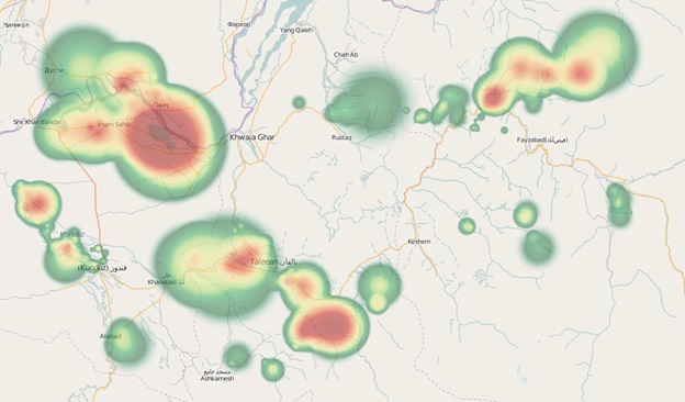
Here is an example of the locations where one volunteer digitized features.
(http://yosmhm.neis-one.org/#)
Future HOT activations are likely to not only request volunteers to provide remote digitizing support, but also GIS analysis support of various projects. Skills that could be needed include overlay analysis, hot spot identification, routing for emergency vehicles, and data validation. GISCorps volunteers with these skills and a good working knowledge of OSM structure and feature tags will be valuable.
The team of 14 volunteers was led by Emmor Nile, a GIS professional from Oregon. Volunteers came from 9 countries: US, Canada, Italy, Russia, Nigeria, Uganda, Sri Lanka, Pakistan, and India: Sonal Raisinghani (Canada), Denis Krivoguz (Russia), Dan Abudu (Uganda), Suthakaran (Sri Lanka), Eleza Boban Kollannur (India), Shahzad Bacha (Pakistan), Kazeem Owolabi (Nigeria), Jomals Mathews John (US), Kinley Winchester (US), Michael Krueger (US), Shrobona Karkun (US), Brynn Lacabanne (US), Francesco Petrosino (Italy), Emmor Nile (US).
Related Missions


