
GISCorps has partnered with TechSoup, an organization focused on empowering nonprofits with technology to build…
Adventure Scientists is a network of volunteers who help fill data gaps for scientists. Adventure Scientists partners with researchers at the forefront of their fields to help solve the world’s environmental and human health challenges. They specialize in recruiting, training, and managing a network of outdoor adventurers to collect high quality field data.
They requested the assistance of a volunteer with ample expertise in conducting an organization-wide GIS Needs Assessment. The Needs Assessment included the following:
- Evaluate the organization’s current GIS ecosystem including its software, hardware, databases, applications, and current skill set;
- Assemble/document the functional needs of the organization (as it relates to GIS);
- Determine how to best use the current resources to fulfill the functional needs in a series of recommendations.
Cristi Delgado, GISP, a seasoned GIS professional who served as the City of Berkeley’s GIS/Geospatial Coordinator for over 12 years was selected for this project and provided the following details after the project was concluded.
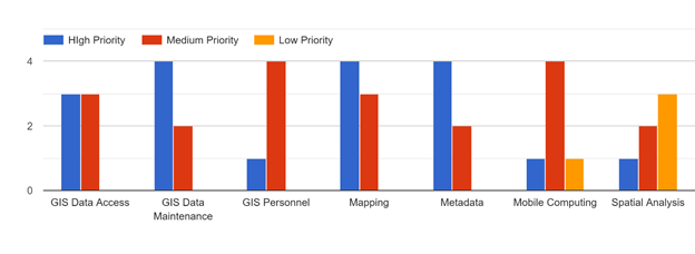
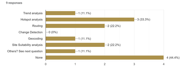
Cristi utilized phone interviews, organization documents and an online survey to evaluate the organization’s current GIS ecosystem including its software, hardware, databases, applications, and current skill set. She documented the GIS needs of the organization and provided recommendations in a 48 page report. Following are a couple of graphs from the Needs Assessment report.
It was an excellent experience. Communication between all parties was clear and helpful. The volunteer for the project was extremely competent and professional.
Katya Koepsel, Adventure Scientists

Related Missions


