Overview The PhotoMappers project is in its ninth year of providing situational awareness to federal,…
Mission with (iMMAP/WFP) – North Korea
Click below for a video demonstrating the hard work of GISCorps volunteers on this project
January 2015 Progress Map

May 2014 Progress Map

November 2014 Progress Map
Here’s the latest report from DPRK management team: ***Drum Roll***
The last tile is being completed today! Many of the completed tiles have already been submitted for final review and edgematching. The map below shows the amazing progress. More than 85 volunteers have worked on this project over the years. Those who are still involved are, not surprisingly, a bit giddy over this news! 🙂

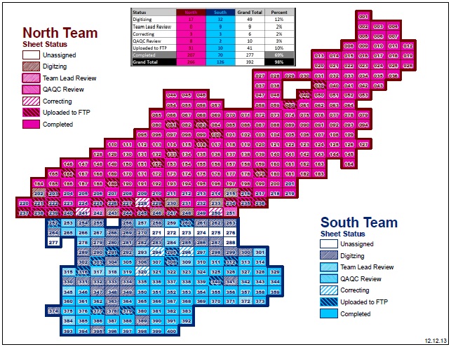
December 2013 Progress Map
February 2014 Progress Map
The DPRK team has reported that every map sheet has been assigned to a volunteer. Remarkable teamwork!

Project Update July/August 2013
The latest Progress Map:

Project Update May 2013
The DPRK project has seen huge progress reaching 50% completed! 350 of the 400 topographic map sheets have been assigned and/or reviewed by 85 volunteers over the past 3 years, including 16 new volunteers from the project’s 6th recruitment that started this week. We still have several volunteers from our first recruitment that took place back in summer of 2010 and have witnessed the project’s dynamic evolution since the beginning. The current status map (from May 25, 2013), locations of the volunteers, and active volunteer list can be seen below:
North Team Digitizers – Team Lead: Patrick Young – TX, USA
- Kirsten Hunt – NC, USA*
- Shannon Gonzales – CA, USA*
- Charles Moser – VA, USA*
- Brian McLeer – OR, USA*
- May Panikom – ON, Canada*
- Beryl Nyamgeroh – Kenya*
- Blake Eickmeyer – CO, USA*
- Jason Reyes – VA, USA*
- Aaron Peck – OH, USA
- Judy Colby-George – ME, USA
- Maria do Carmo Dias Bueno – Rio, Brazil
- Jasmine Ward – PA, USA
- Emanuele DiTullio – IL, USA
- Alex Woldemichael – MD, USA
- Trevor Allen – UK
- Barasa Bernard – Uganda
- Svetla Borovska – NY, USA
- Tom Lee – CO, US
South Team Digitizers – Team Lead: Chris Zumwalt CA, USA
- Douglas Burns – TX, USA*
- John Hudler – GA, USA*
- Andrew Cole – CA, USA*
- Allison Bradshaw – CT, USA*
- Samantha Edwards – VA, USA*
- Bakhtali Mohammad – Saudi Arabia*
- Damien Bulter – Ireland*
- Jordan Abbott – PA, USA
- Eric Pena – TX, USA
- John Foster – WA, USA
- Rachel Clark – TX, USA
- Bridgette Robinson – VA. USA
- John DeGroote – IA, USA
- Nicholas Hayden – CA, USA
- Olufisola Oladipo – Nigeria
- Paul Giers – NC, USA
- Laura Miles – BC, Canada
- Jane Muriithi – Kenya
- Jim Olson – MN, USA
- Andrea Parish – MD, USA
- Christian Schumann – OR, USA
- Kerry Shakarjian – CO, USA
- Azin Sharafeddian – NY, USA
- Amy Sorensen – NE, USA
- Kait Taha – MN, USA
QAQC Team – Team Lead: Scott Oatley – MN, USA
- David Litke – CO, USA
- German Whitley – OR, USA
- Francesco Petrosino – Salerno, Italy
- Kelli Brock – NV, USA
- Naiara Fernandez – Germany
- Helen Hands – KS, US
* New Recruit
Advisory Team
- Karen Payne – GA, USA – Data repository, final QAQC, Protocol development
- Carol Kraemer – GA, USA – Google Docs/Site development, various tasks

Status Map as of May 2013

Locations of active and retired volunteers (pushpins are retired volunteers)
Project Update December 2012
DPRK team has made an impressing progress in 2012. The following map shows the rate of progress.

Status Map as of December 2012
Project Update May 2012
The management team recently requested additional volunteers. A call for volunteers went out and 20 volunteers were selected. This was DPRK’s 5th recruitment and to date a total of 67 volunteers have been deployed to this project. Our newest volunteers are from seven countries: US, UK, Canada, Germany, Uganda, Kenya, and Australia. They are:
Trevor Allen (UK); Barasa Bernard (Uganda); Nathan Bruce & Laura Miles (Canada); Naiara Fernandez (Germany); Jane Muriithi (Kenya); James Paull (Australia); Svetla Borovska, Kelli Brock, Mark Drew, Helen Hands, Ji-Young Kim, Tom Lee, Jim Olson, Andrea Parish, Christian Schumann, Kerry Shakarjian, Azin Sharaf, Amy Sorensen, & Kait Taha (USA).
Project Update February 2012
Many changes are under way after the projects 4th recruitment back in October. In addition to having two teams of volunteers digitizing tiles, a QAQC team has been established and is being managed by South Team veteran volunteer, Scott Oatley. Scott and his team will be speeding up the workflow as tiles are being digitized at a faster pace. The project has seen a dramatic increase in production with 20 tiles alone between October and December!
David Litke, Duane Hanstein, and German Whitley have earned serious bragging rights for their contributions to this achievement. Though Dave Litke only joined the DPRK team back in October of 2011, as a digitizer on the north team, he has made a huge impact. In his four months on the project, he has digitized more than 39 tiles! He has also made a concerted effort to find ways of streamlining the project through documenting and sharing procedures as well as building and sharing custom GIS tools. His speed and efficiency have also earned him a spot on the QC Team, which has helped to further speed up progress on the project. The team greatly appreciates all the effort Dave has put in and hopes he will continue for a long time to come. German Whitley has digitized 18 separate sheets for the DPRK South Team since she joined the project in 2010. A project of this magnitude takes a lot of time and effort from our volunteers and German’s work has been invaluable. We owe her much gratitude and many thanks for all of the personal time and skillful digitizing she has contributed.
Carol Kraemer continues the enhancement of the Google website and tool creation to support the project teams. Check out the DPRK’s new volunteer Profile Page to get to know our hard working team better!

Status Map as of February 2012
Project Update October 2011
The 4th recruitment for DPRK mission resulted in deploying 14 new volunteers who will be joining the existing team of 20 volunteers. These volunteers come from four countries (US, Italy, Nigeria, and Tanzania) and are now in contact with the management team. The following is a list of new volunteers and project managers and advisors:
Volunteers:
- From US: Alex Woldemichael – MD, Bryan Parlee – CA, Daniel Ngoroi – OH, David Litke – CO, Duane Hanstien – CO, Emanuele DiTullio – IL, Jennifer Horsman – CO, John De Groote – IA, Nick Hayden – CA, Paul Giers – N. Carolina, William Craft – KS
- From Italy: Francesco Petrosino
- From Nigeria: Olufisola Oladipo
- From Tanzania: Langen Mathew Mallya
Project Managers and advisors:
- Chris Zumwalt, CA – Project Manager (South Team)
- Patrick Young, TX – Project Manager (North Team)
- Scott Oatley, MN – QC Manager
- Karen Payne, GA; University of Georgia’s Information Technology Outreach Services (ITOS) – Project Advisor
- Carol Kraemer, GA – Project Advisor and former Project Manager for the North team
Project Update May – August 2011
Many more map sheets have been digitized and QC’ed since May. The management team has sent another opt-out email to the volunteers and is now preparing for the next recruitment. Additional volunteers will be needed for both digitizing and also for QC tasks.
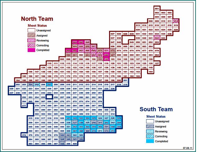
Status Map as of July 2011
Project Update February – May 2011
The third round of recruitment and the project in general is going very well and more map sheets are digitized by the volunteers. The pace at which the scanned sheets are being digitized has increased due to volunteer’s familiarity with the complicated digitizing protocol and the addition of new volunteers. After the completion of the first six month period of the project, volunteers were given the option to opt out. Retention of volunteers has been excellent for out of 30 volunteers, 23 have decided to stay. This will contribute greatly to the progress of the digitizing as these veterans are already familiar with the protocol, using the Google sites, the QA/QC process, and the exchange of data sets with the managers. After evaluation of the first round of this project, progress is going so well that management is gearing up for a third round of recruitment. So far, three volunteers have joined the team and they are: Pauline Peters, Tom Torres, and Hillary Woodall, all from Gainesville State College in Georgia. More are to be added to the team soon so look for a status update shortly.
Project Update – October 2010
The project has been evolving since the introduction of the first 20 patient volunteers and progress has been more so realized in the work taking place behind the scenes than in the number of sheets completed. The pace is now picking up after changes were made to improve the already comprehensive protocol and with the recent addition of more volunteers. The geodatabases used for data creation have been updated with topology to streamline the digitizing process and QAQC. Collaboration and coordination of information, support, and files have been vital given the distribution of volunteers and the remote nature of this effort. For these reasons, it was obvious early on that email alone would not be enough to satisfy the communication needs. This project is, therefore, making good use of the Google suite of tools available. Recently, a website was created using Google Sites (screenshots below) which allows collaborative documents that were already stored within Google Docs to be shared as well as providing a blog-like discussion format to keep the group connected. This ensures that information remains current to the volunteers at all times.

Screenshot of volunteers’ website (Main Page)

Protocol stored within Google Docs is embedded in the website. Changes to the document are immediately available to view on the website
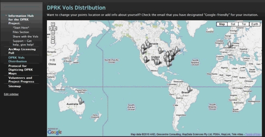
Locations of volunteers working on the DPRK project
Project Background
Eight (8) additional volunteers have been recruited for North Korea project and that brought the total number of volunteers to 30 (including two project managers – Carol Kraemer and Chris Zumwalt). The request for volunteers came from the World Food Program (WFP) and Information Management and Mining Action Program (iMMAP). Volunteers are charged with the task of digitizing 400 map sheets and will create several data layers such as: settlement points, transportation (roads, foot path, and railroads), rivers and lakes. Members of the team are:
Chris Zumwalt, California – Project Manager
Carol Kraemer, Georgia – Project Manager
Karen Payne, Gerogia; University of Georgia’s Information Technology Outreach Services (ITOS) – Project Advisor
Data Entry Team:
Christopher Storer, Ohio
Dustyn Palmer, Georgia
Ehren Hill, Germany
Eric Pena, Texas
Gabriel Peck, Ohio
John Foster, Washington
Judy Colby-George, Maine
Julie Stamper, North Carolina
Justin Cole, New York
Krista Anderson, Florida
Kyle Watts, Australia
Maria do Carmo Dias Bueno, Brazil
Natalie Zabcic, Canada
Rachel Clark, Texas
Randal Hale, Tennessee
Rebecca Basquez, texas
Ryan Jillard, Canada
Scott Oatley, Minnesota
Sharon Jones, Pennsylvania
Lindsay Weir, Pennsylvania
Will Reckling, N. Carolina
Patrick Young, Texas
Jasmine Ward, Pennsylvania
German (Mary) Whitley, Oregon
Maria Hack , Georgia
Siqin (Sisi) Wang, Pennsylvania
Bridget Robinson, Virgina
Michael Rochelle, California
History of the project
The original request for volunteers came from the World Food Program (WFP) and Information Management and Mining Action Program (iMMAP) in 2009. Volunteers are charged with the task of digitizing 400 map sheets and will create several data layers such as: settlement points, transportation (roads, foot path, and railroads), rivers and lakes. Following their request, GISCorps posted the information on its website and was then contacted by Karen Payne of ITOS who expressed interest in assisting with the project. During the first phase, she conducted tests to determine the best options for rectification of scanned maps and forwarded the results to WFP. She then continued the test by investigating various methods for extracting features from those scanned maps.
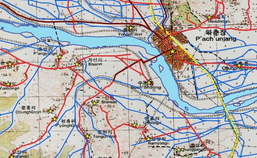
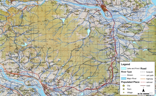 | |||||
| Zoomed into one sheet (map is overlaid with digitized features) | |||||
We then brought in another volunteer, Chris Zumwalt, a GIS Manager with WRA Inc. CA, who joined the team to run a pilot project and determine the best methodology for compiling these features. The pilot project which was conducted on two separate sheets involved running two separate processes:
1) cleaning up vectorized features generated by University of Georgia methodology
2) conduct Heads-Up (HUD) digitizing
 | |||||
| Zoomed into one sheet | |||||
The final result of the pilot project determined that HUD was the preferred method for compiling most of the features. For some water features however, ITOS’ extracted features will be used as a starting point. The results of the pilot project were then sent to iMMAP/WFP representatives and their feedback was reflected on the procedure.
 | |||||
| Zoomed into one sheet | |||||
We then brought in another Project Manager, Carol Kraemer, a GISCorps volunteer from Georgia who along with Chris and Karen determined the number of required volunteers for digitizing 400 map sheets. All the volunteers were recruited in early May.
An FTP site was developed for the volunteers to check the datasets in and out. This dataset will go through a QA/QC process, be edge matched, and integrated into the final geodatabase for delivery to iMMAP/WFP.
The World Food Programme uses Geographic Information Systems (GIS) software and data to produce maps in support of its humanitarian operations worldwide. WFP routinely works with commercial companies, government institutions, and its network of humanitarian partners to develop or improve GIS data for the countries where it has ongoing operations. These data are used for emergency preparedness, needs assessment and food security analysis, monitoring and evaluation, as well as operational planning.
Check this page for future updates.[/vc_column_text]
Project Update October/November 2013
The latest Progress Map:

Related Missions


