Overview The PhotoMappers project is in its ninth year of providing situational awareness to federal,…
GISCorps volunteer assists a non-profit organization in Guatemala
On October 20, 2008, GISCorps received a request from a group of volunteers who were assisting a Guatemalan NGO, Pastoral Commission Peace and Ecology (COPAE) to monitor and diagnose damage to indigenous people’s homes near the Marlin Mine in the vicinity of Sipacapa, Guatemala. They were interested in obtaining hard copy maps from high resolution imagery and base data. They also wanted the imagery to become accessible to them in Google Earth (GE) environment. GISCorps volunteer, Lars Bromley of Washington D.C. was contacted for this project. He was able to geo-reference and overlay a high resolution imagery which was provided by Digital Globe in GE interface.
 | |||||
| Figure 1: Location Map. © Google Earth and Digital Globe. Inset © Europa Technologies, INEGI, Terrametrics, and LeadDog Consulting. | |||||
Since then the group has produced a detailed report in both English and Spanish (links to both versions and the appendices at the end of this report) on the results of their research and analysis and Lars continues to assist the group with plotting more maps and providing other support information.
 | |||||
| Figure 2: Crack from window or door to roof beam | |||||
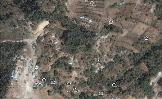 | |||||
| Figure 3: 7. Map of Buildings Observed in Escupija. © Google Earth and Digital Globe. | |||||
– Link to report in English (Preliminary Investigation and Analysis of Building Damage in the Villages of Agel, San José Ixcaniche, and San José Esperanza) –
– Link to report in Spanish (Investigación y Análisis Preliminares de Daños a las Casas en las Aldeas de Agel, San José Ixcaniche, and San José Esperanza)
Related Missions


